Tipping Point Season:
See the AMOC Sea
The important question, therefore, is no longer simply:
“Which tipping point are we approaching?”
It is:
“What happens when tipping points begin interacting?”
That is the essence of Tipping Point Hunting Season. We are not hunting for a single point on a graph. We are watching for the connections as they become impossible to ignore.
How a Pacific El Niño Can Reroute Climate Energy Across the Planet
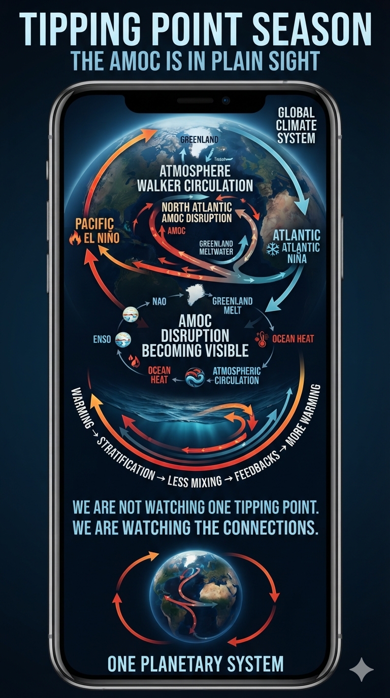
The first time the global temperature was sustained above 1.5°C was during the 2023–2024 El Niño. The reason 1.5°C is critical is its potential tripwire effect. It is a temperature level at which feedbacks can become self-reinforcing and begin coupling with other tipping points and feedback mechanisms.
The 2023–2024 Season
1. The Dynamic Influence Is Primarily Reversed
Recent climate modeling demonstrates that the directional influence is actually the opposite of what might be assumed: a weakening Atlantic Meridional Overturning Circulation (AMOC) actively strengthens El Niño variability.
As the AMOC slows because of global warming, it reduces the annual sea-surface-temperature cycle in the eastern equatorial Pacific. This amplifies ENSO (El Niño–Southern Oscillation) variability by roughly 11% and shifts the pattern toward more frequent Central Pacific El Niño events.
2. Atmospheric Teleconnections
The 2023–2024 El Niño altered the global zonal Walker circulation. This shift can affect the North Atlantic Oscillation (NAO) through large-scale atmospheric loops.
Because the NAO heavily influences wind patterns and winter temperatures over the North Atlantic, these El Niño-driven atmospheric shifts can indirectly modulate the surface currents that feed the AMOC.
3. Compounding Global Marine Stress
The 2023–2024 El Niño was the fifth-most powerful on record and temporarily drove global temperatures to unprecedented highs.
It stacked massive amounts of heat on top of an Atlantic basin that was already experiencing severe marine heatwaves. This extreme global warmth contributes to accelerated melting of the Greenland Ice Sheet and increased northern rainfall.
The resulting massive influx of buoyant freshwater dilutes the salinity of the North Atlantic, preventing water from sinking and pushing the AMOC closer to its projected tipping point.
The 2026–2027 Season
The simultaneous occurrence of an extreme Pacific Super El Niño and an anomalous Atlantic Niña represents a significant disruption of historically observed ocean–atmosphere interactions.
These coupled climate anomalies illustrate how anthropogenic warming is altering the baseline state of Earth’s climate system, reducing predictability, amplifying hydroclimatic extremes, and accelerating interconnected feedback mechanisms.
While an Atlantic Niña pattern may temporarily suppress Atlantic hurricane activity through increased atmospheric stability and wind shear, this short-term effect masks deeper systemic changes occurring within global ocean circulation, carbon cycling, and energy redistribution.
Climate change is increasingly modifying the physical conditions under which natural climate oscillations such as El Niño–Southern Oscillation (ENSO) and Atlantic Niño variability operate.
Warmer ocean surfaces, enhanced stratification, declining vertical mixing, and changing circulation patterns are transforming previously stable climate relationships into increasingly nonlinear and difficult-to-predict interactions.
These changes threaten to intensify global precipitation extremes, weaken ocean carbon sequestration, and accelerate reinforcing feedback loops involving greenhouse gas emissions, ocean warming, and cryosphere loss.
The currently developing El Niño exemplifies the supercharged climate energy accumulating in the system.
The 2026 ocean–atmosphere configuration illustrates how climate variability can interact with long-term warming trends to activate reinforcing feedback mechanisms.
A simplified representation is:
Ocean Warming
↓
Stronger Stratification
↓
Reduced Mixing
↓
Increased Greenhouse Gas Release
↓
Accelerated Warming
↓
Further Ocean Warming
These feedbacks transform climate change from a linear response into a nonlinear system in which small perturbations can trigger increasingly larger consequences.
Rerouting the Walker Circulation:
The Pacific El Niño–Atlantic Niña Atmospheric Bridge
The unusual co-occurrence of a Pacific El Niño and an Atlantic Niña illustrates how strongly connected Earth’s climate system is.
Although the Pacific and Atlantic are separate ocean basins, the atmosphere links them through planetary-scale circulation patterns.
One of the most important connections is the Walker circulation—a vast east–west circulation of rising and sinking air across the tropics.
When El Niño warms the central and eastern tropical Pacific, it reorganizes convection, atmospheric pressure, and wind patterns across the tropics. Those changes can extend into the Atlantic, altering the trade winds and ocean circulation there.
The result is a remarkable sequence of interconnected processes:
Pacific warming → atmospheric rerouting → Atlantic pressure changes → stronger trade winds → enhanced upwelling → Atlantic cooling
1. Rerouting the Walker Circulation
Walker Circulation / ENSO Teleconnection
The Walker circulation is a large-scale tropical atmospheric circulation that links changes in convection, pressure, winds, and ocean–atmosphere heat exchange across the Pacific and beyond.
During El Niño, changes in Pacific sea-surface temperatures reorganize this circulation, creating atmospheric teleconnections that can extend into the Atlantic.
Pacific Warming
During El Niño, unusually warm surface waters develop across the central and eastern tropical Pacific.
The additional oceanic heat increases evaporation and fuels stronger deep atmospheric convection.
Shifted Convection
As warm, moisture-rich air rises over the anomalously warm Pacific, the center of tropical convection shifts eastward.
This changes the pattern of rising and sinking air that defines the Walker circulation, redistributing atmospheric energy and altering pressure and wind patterns across the tropics.
Atlantic Subsidence
The reorganized tropical circulation can produce compensating regions of sinking, relatively dry air over parts of the tropical Atlantic and Caribbean.
This subsidence suppresses cloud formation and deep convection and can contribute to higher surface pressure.
The Atmospheric Bridge
The Pacific warming does not directly “cause” the Atlantic to cool.
Instead, ENSO reorganizes the atmospheric circulation, and that planetary-scale response can alter Atlantic pressure, winds, evaporation, and ocean circulation—providing the atmospheric bridge between the two ocean basins.
2. The Planetary Teleconnection:
From the Pacific to the Atlantic and Beyond
The ENSO teleconnection does not stop at the Atlantic.
The atmospheric disturbance generated by El Niño can propagate across the tropics and into the extratropics, linking the Pacific to the Atlantic, North Atlantic, Europe, and the United Kingdom through a network of atmospheric circulation patterns.
As tropical convection shifts over the Pacific, it alters the distribution of atmospheric heating.
These changes can generate large-scale Rossby waves that propagate through the atmosphere, modifying the position and strength of the jet streams, storm tracks, and persistent pressure systems far from the original Pacific anomaly.
Pacific → Atlantic
The first major connection is the tropical Atlantic:
Pacific El Niño
↓
Shifted tropical convection
↓
Walker circulation response
↓
Changes in tropical pressure and winds
↓
Atlantic trade-wind response
↓
Ocean circulation and sea-surface-temperature changes
This atmospheric bridge helps explain how a warming anomaly in the Pacific can coincide with cooling in the tropical Atlantic.
Atlantic → North Atlantic → Europe
The teleconnection can extend farther north.
Changes in tropical heating and atmospheric wave patterns can influence the North Atlantic jet stream and pressure fields, including variations associated with the North Atlantic Oscillation (NAO).
These changes can alter the path of Atlantic storms and the transport of heat and moisture toward Europe.
The United Kingdom sits downstream of this North Atlantic circulation and can therefore experience changes in the probability of particular weather regimes—even though the original oceanic disturbance began thousands of miles away in the tropical Pacific.
The relationship is probabilistic, not deterministic.
ENSO is one influence among many, and the eventual European response depends on the season, the state of the North Atlantic, stratospheric conditions, and other interacting climate modes.
A Planetary Feedback Network
The important point is that this is not a simple one-way pipeline.
PACIFIC
El Niño
↓
ATMOSPHERE
Walker circulation + planetary waves
↓
ATLANTIC
Trade winds + ocean response
↓
NORTH ATLANTIC
Jet stream + NAO
↓
EUROPE / UK
Weather-pattern response
↓
GLOBAL OCEAN–ATMOSPHERE SYSTEM
↓
PACIFIC
The final connection back toward the Pacific should not be interpreted as a single atmospheric current literally traveling around the planet.
Instead, it represents coupled feedbacks within the global climate system.
Changes in one ocean basin alter atmospheric circulation; those atmospheric changes affect other ocean basins and land surfaces; and those changes can subsequently feed back into the global circulation system.
ENSO is therefore not simply a Pacific phenomenon.
It is a planetary-scale disturbance that can reorganize atmospheric and oceanic conditions across multiple basins and continents.
One ocean warms.
The atmosphere responds.
The response travels.
The planet adjusts.
3. Amplification of Atlantic Trade Winds
Pressure Gradients
The redistribution of rising and sinking air modifies sea-level pressure across the tropical Atlantic.
A stronger pressure gradient can develop along the equatorial Atlantic.
Stronger Easterly Winds
The resulting pressure gradient can strengthen the Atlantic trade winds.
These persistent easterlies are critical because they directly interact with the ocean surface.
The atmosphere has effectively rerouted part of the Pacific’s excess energy through a planetary-scale circulation response, creating conditions that can cool a distant ocean basin.
4. Wind-Driven Ocean Upwelling
Surface-Water Displacement
Stronger easterly trade winds push warm surface waters westward across the equatorial Atlantic and alter the distribution of ocean heat.
Cold Water Rises
As surface waters are displaced, deeper, colder water can rise toward the surface through equatorial upwelling.
This water is typically cooler and richer in nutrients than the surface layer.
The Atlantic Niña Emerges
When the resulting cooling is sufficiently strong and persistent, tropical Atlantic sea-surface temperatures can fall substantially below normal, producing the characteristic cold anomaly known as an Atlantic Niña.
The Atlantic cooling is therefore not an isolated ocean event.
It can be part of a larger coupled atmosphere–ocean response initiated thousands of miles away in the Pacific.
The Atmospheric Shield:
A Planetary Teleconnection Comes Full Circle
When a Pacific El Niño and an Atlantic Niña occur together, their effects can reinforce one another over the tropical Atlantic.
But the hurricane response is only one part of a much larger planetary circulation story.
The sequence begins thousands of miles away:
Pacific El Niño
↓
Rerouted Walker circulation
↓
Planetary atmospheric teleconnection
↓
Atlantic pressure + wind changes
↓
Stronger trade winds
↓
Enhanced equatorial upwelling
↓
Atlantic Niña / cooler tropical Atlantic
The resulting Atlantic conditions can then influence tropical cyclone development.
El Niño tends to increase vertical wind shear, disrupting the organization of developing tropical cyclones.
At the same time, cooler tropical Atlantic waters reduce the oceanic heat available to support deep convection and storm intensification.
Together, these effects can create an atmospheric shield over the Atlantic hurricane-development region:
ATLANTIC NIÑA
Cooler ocean
↓
Less convective energy
EL NIÑO
Pacific warming
↓
Stronger vertical wind shear
↓
COMBINED EFFECT
↓
Less favorable conditions for Atlantic tropical cyclones
This does not mean an Atlantic hurricane season becomes impossible.
Tropical cyclone activity depends on many interacting factors, including sea-surface temperatures, atmospheric moisture, vertical wind shear, African easterly waves, upper-level circulation, and broader Atlantic climate conditions.
One Planetary System
What makes this Tipping Point Hunting Season different is that the connections between climate systems are becoming increasingly visible.
The AMOC is no longer something happening quietly in the background of the climate system. Its disruption is beginning to show up through the behavior of the systems connected to it. The weakening of the AMOC can alter the conditions that shape ENSO variability, while El Niño can reorganize atmospheric circulation that reaches back into the North Atlantic. Greenland melt and increased northern rainfall add freshwater to the North Atlantic, further affecting the density and sinking of seawater that helps drive the AMOC.
This is the critical distinction between looking for individual tipping points and watching the climate system itself.
A tipping point does not necessarily announce itself as one spectacular event. It can emerge as a growing loss of stability—a system that responds differently than it once did, feedbacks that begin reinforcing one another, and formerly separate climate oscillations that increasingly interact.
The 2026–2027 Pacific El Niño–Atlantic Niña configuration provides another window into that process. The Pacific, Atlantic, North Atlantic, and atmosphere are not operating independently. Energy is being redistributed among them through circulation, pressure, winds, ocean mixing, heat storage, and freshwater fluxes.
And that brings us back to the AMOC.
The AMOC is not merely another potential tipping point waiting somewhere in the future. It is part of the circulation architecture connecting the climate system together. As that circulation is disrupted, the consequences can propagate outward—changing ocean temperatures, atmospheric circulation, storm tracks, precipitation patterns, and the behavior of other climate modes.
That is why the AMOC disruption is much more noticeable in this Tipping Point Hunting Season.
We are beginning to see the fingerprints of a changing circulation system in places that, at first glance, appear unrelated.
A Pacific ocean anomaly can alter the atmosphere. The atmosphere can alter the Atlantic. The Atlantic can alter the North Atlantic. The North Atlantic can influence Europe. Freshwater entering the North Atlantic can further disrupt the circulation that connects these systems. And the resulting changes can feed back into the system again.
This is not a collection of separate climate problems. It is a coupled system increasingly operating outside the conditions under which we learned to understand it.
The important question, therefore, is no longer simply:
“Which tipping point are we approaching?”
It is:
“What happens when tipping points begin interacting?”
That is the essence of Tipping Point Hunting Season. We are not hunting for a single point on a graph. We are watching for the moment when the connections between the points become impossible to ignore.
One ocean warms.
Another cools.
The atmosphere reroutes the energy.
The circulation changes.
The feedbacks respond.
And the planet adjusts.
The AMOC is one of the clearest places to watch that adjustment happening.
Read the full hunting manual: This is Tipping Point Season
Easy-to-Read Resources